Pre-Development - the 1870s and 1880s
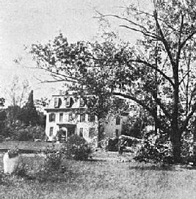
Belmont, the Richard Lloyd house, was sold to the county for a high school around 1921, then to the Episcopal Diocese of Virginia in 1924 to found St Agnes School. Beautifully preserved it still serves, now as the school's administrative building (1924 Photo provided by the St. Stephen's & St. Agnes School Archives)
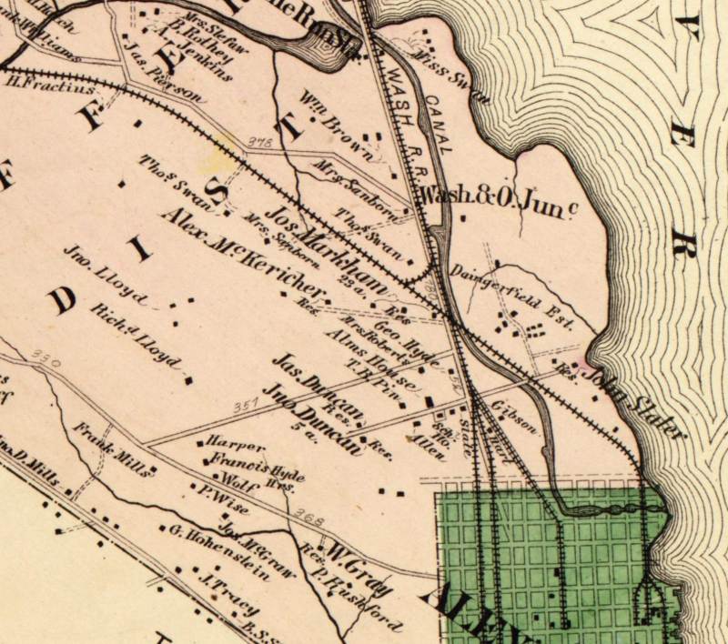
The 1878 map shows the main land holders in what would become the Del Ray area. In the year following Frank Hume would acquire Thomas Swann's more western house and rename it Warwick. The road parallelling the "Wash RR" is now US1, the road underneath the "u" of "Jas Duncan" is now Bellefonte, even then running from US1 to Braddock, the road ending at the "a" in Jno Duncan is Monroe, the dirt trail leading to the Alex McKericher house is now Mt Ida, and the road above "Mrs Sanborn" is Glebe.
Warwick, the Hume home, was abandoned and fell into disrepair in the 1940s. It was demolished in 1951 to make way for the Warwick Village development.
The area that is now Del Ray was included in the tract acquired indirectly from the King in 1669 by John Alexander, after whom Alexandria is named. By 1800 the area bounded by Four Mile Run in the north, the Potomac River on the east, what is now Braddock Road on the south and the present Cameron Mills Road to the west was held by Charles Alexander Jr, a sixth-generation descendant of John. He married Mary Bowles Armistead in 1800 and shortly thereafter built grand home that he named “Mount Ida”on a hill to overlook the eastern, flatter, portion of his property.
Charles' widow married a Dr. Wilson Seldon and their daughter Eliza Seldon purchased the property in 1845. Shortly thereafter she married John Janney Lloyd, who was the son of John Lloyd (owner of Lloyd house in Alexandria) and Rebecca Janney. Some of the Mt Ida farm was purchased by John J's brother Richard shortly after the civil war and he put up his own house, known as Belmont, in the Victorian gingerbread style, around 1870.
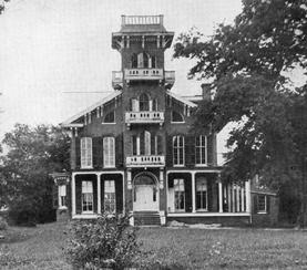
The third major landowner in the area was Frank Hume, a former Confederate soldier who had become wealthy in the wholesale grocery trade in DC. He bought the estate and house known as Warwick in 1879 from Thomas Swann and moved there, becoming a major factor in the development northern Virginia, including serving two terms in the Virginia House of Delegates and donating land for the Hume School on Arlington Ridge Road.
By 1890 the large landowners were John J Lloyd with Mt Ida at 207 acres, Richard Lloyd in Belmont at 175 acres, and Frank Hume in Warwick at 144 acres (not counting his 144 acres of Abingdon plantation). Across the railroad tracks and the turnpike to the east were holdings of the Daingerfield clan, totaling 208 acres. Smaller landholders included Alexander McKerichar, developing a racetrack on 23 acres near the center of area, and two unrelated Duncan families on Poorhouse (now Monroe) Avenue, James with 40 acres and John with 5.
Passing north from the city along the Alexandria-Washington Turnpike (now Jeff Davis Hwy), adjacent to the Washington Railroad shown on the map, one would have seen open fields on both sides. The dominant crop was hay, essentially grass. During Spring to Fall the grass would grow to about knee height and then be cut down by crews with scythes, left to dry on the ground, and then raked up onto wagons. The farms generally got four such harvests during the growing season. Much smaller plots were given over to corn, wheat, fruit trees and vineyards.